Lesotho
Tampilan
29°36′S 28°18′E / 29.6°S 28.3°E
Kingdom of Lesotho 'Muso oa Lesotho (Sesotho)
| |
|---|---|
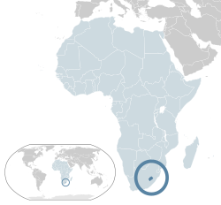
 Location of Lesotho (dark blue) – in Africa (light blue & dark grey) Location of Lesotho (dark blue) – in Africa (light blue & dark grey) | |
| Ibu kota | Maseru 29°28′S 27°56′E / 29.467°S 27.933°E |
| Basa resmi | |
| Kelompok étnis |
|
| Demonim |
Lesothan (Interchangeable) Lesothonian |
| Pamréntahan | Unitary parliamentary constitutional monarchy |
• Monarch | Letsie III |
| Tom Thabane | |
• Deputy Prime Minister | Monyane Moleleki |
| Sephiri Motanyane | |
| Legislatip | Parliament |
| Senate | |
| National Assembly | |
| Independence | |
• from the United Kingdom | 4 October 1966 |
| Jimbarnyané | |
- Total | 30,355 km2 (11,720 sq mi) (137th) |
| 0.0032% | |
| Populasi | |
- Perkiraan 2016 | 2.203.821[1] (144th) |
- Sensus Krama 2004 | 2,031,348 |
| 68.1/km2 (176.4/sq mi) (138th) | |
| PDB (KKB) | 2017 |
- Total | $7.448 billion[2] |
| $3,868[2] | |
| PDB (nominal) | 2017 |
- Total | $2.721 billion[2] |
| $1,413[2] | |
| Gini (2015) | 54.2[3] tinggi · 17 |
| IPM (2018) | rendah · 164th |
| Mata uang | Lesotho loti (LSL), South African rand (ZAR) |
| Zona waktu | South African Standard Time (UTC+2) |
| Lajur kemudi | left |
| Kode télépon | +266 |
| Kode ISO 3166 | [[ISO 3166-2:LS
|LS ]] |
| Ranah Internet | .ls |
Estimates for this country explicitly take into account the effects of excess mortality due to AIDS; this can result in lower life expectancy, higher infant mortality and death rates, lower population and growth rates, and changes in the distribution of population by age and sex than would otherwise be expected. | |
Lesotho (/ləˈsuːtuː/ (ⓘ),[5] Mal:IPA-st) inggih punika silih tunggil negari ring benoa Afrika. Negari puniki jimbarnyané 30,355 km² miwah akeh kramanyané kirang langkung 1,894,194 diri.
- ↑ "World Population Prospects: The 2017 Revision". ESA.UN.org (custom data acquired via website). Departemen_Urusan_Ekonomi_dan_Sosial_PBB, Population Division. Kaaksés 10 Séptémber 2017.
- ↑ 2,0 2,1 2,2 2,3 "Lesotho". International Monetary Fund.
- ↑ "GINI index". World Bank. Kaarsipin saking versi asli tanggal 8 April 2016. Kaaksés 31 Maret 2016.
- ↑ "Human Development Report 2019" (PDF) (ring Inggris). United Nations Development Programme. 10 December 2019. Kaaksés 10 December 2019.
- ↑ "lesotho noun - Definition, pictures, pronunciation and usage notes | Oxford Advanced Learner's Dictionary at OxfordLearnersDictionaries.com". www.oxfordlearnersdictionaries.com (ring Inggris). Kaarsipin saking versi asli tanggal 11 Maret 2018. Kaaksés 10 Maret 2018.
- Boyd, J. Barron (December 1979). "African Boundary Conflict: An Empirical Study". African Studies Review. 22 (3): 1–14. ISSN 0002-0206. JSTOR 523892.CS1 maint: ref=harv (link)
| Scholia gelah topic profil manut Lesotho. |
- Government of Lesotho
- Published Judicial Opinions
- "Lesotho". The World Factbook. Central Intelligence Agency.
- Lesotho from UCB Libraries GovPubs
- Lesotho ring Curlie
- Lesotho profile from the BBC News
 Peta Lesotho ring Wikimedia Atlas
 Data geografis Lesotho di OpenStreetMap
- Key Development Forecasts for Lesotho from International Futures


