Kota New York
Tampilan
| New York | |||||
|---|---|---|---|---|---|
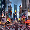
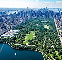
Midtown Manhattan sareng Gedung Empire State (tengah) lan Manhattan Sor sareng One WTC (latar ungkur) | |||||
| |||||
| Julukan: | |||||
| Koordinat: 40°42′46″N 74°00′22″W / 40.71278°N 74.00611°W[2] | |||||
| Country | |||||
| Negara wagian | |||||
| County konstituén (borough) | Bronx (The Bronx) Kings (Brooklyn) New York (Manhattan) Queens (Queens) Richmond (Staten Island) | ||||
| Kamenengin | 1624 | ||||
| Konsolidasi | 1898 | ||||
| Asal nama | James, Duke York | ||||
| Pamréntahan | |||||
| • Jenis | Déwan-Walikota kuat | ||||
| • Lembaga | Déwan Kota New York | ||||
| • Walikota | Eric Adams (D) | ||||
| Jimbar | |||||
| • Total | 472,43 sq mi (1.223,59 km2) | ||||
| • Darat | 300,46 sq mi (778,18 km2) | ||||
| • Air | 171,97 sq mi (445,41 km2) | ||||
| Titik pinih tegeh | 401 ft (122 m) | ||||
| Titik pinih endep | 0 ft (0 m) | ||||
| Populasi | |||||
| • Total | 8.804.190 | ||||
| • Perkiraan (July 2022)[4] | 8.335.897 | ||||
| • Peringkat | ka-1 ring Amérika Serikat ka-1 ring Negara Wagian New York | ||||
| • Kepadatan | 29.302,66/sq mi (11.313,81/km2) | ||||
| • Kota | 19.426.449 | ||||
| • Kepadatan kota | 5.980,8/sq mi (2.309,2/km2) | ||||
| • Metro | 20.140.470 | ||||
| Demonim | New Yorker | ||||
| GDP | |||||
| • Total | $1.21 triliun (2022) | ||||
| • Métro | $2.16 triliun (2022) (ka-1) | ||||
| Wewidangan galah | UTC–05:00 (EST) | ||||
| • Musim panas (DST) | UTC–04:00 (EDT) | ||||
| Kode pos | 100xx–104xx, 11004–05, 111xx–114xx, 116xx | ||||
| Kode wawengkon | 212/646/332, 718/347/929, 917 | ||||
| FIPS code | 36-51000 | ||||
| GNIS feature ID | 975772 | ||||
| Situs web | www | ||||
New York, taler kasengguh Kota New York[lower-alpha 2] utawi kaancengang 'NYC, inggih punika kota pinih padet ring Amérika Serikat, magenah ring ujung kelod Negara Wagian New York ring silih tunggil labuhan alami pinih ageng ring jagat. Kota niki madaging lima borough, sané soang-soang pateh jimbarné sareng wawidangan liyanan.
- ↑ Nigro, Carmen. "So, Why Do We Call It Gotham, Anyway?", New York Public Library, 25 Januari 2011. Kaaksés tanggal 3 Maret 2023. "It is here that we learn that the term Gotham is tied to the author Washington Irving, famous for his short stories 'The Legend of Sleepy Hollow,' and 'Rip Van Winkle.' It's also here that we learn Irving was being less than flattering when he nicknamed the city in 1807."
- ↑ "US Gazetteer files: 2010, 2000, and 1990". United States Census Bureau. February 12, 2011. Kaaksés April 23, 2011.
- ↑ "ArcGIS REST Services Directory". United States Census Bureau. Kaaksés September 20, 2022. Check date values in:
|access-date=(help) - ↑ 4,0 4,1 QuickFacts for New York city, New York; New York; United States, United States Census Bureau. Accessed January 12, 2024.
- ↑ "List of 2020 Census Urban Areas". census.gov. United States Census Bureau. Kaaksés January 8, 2023.
- ↑ "2020 Population and Housing State Data". United States Census Bureau. August 12, 2021. Kaaksés November 24, 2021.
- ↑ "Gross Domestic Product by County and Metropolitan Area", fred.stlouisfed.org
- ↑ "Total Gross Domestic Product for New York-Newark-Jersey City, NY-NJ-PA (MSA)", fred.stlouisfed.org
- ↑ "US Board on Geographic Names". Survéi Géologi Amérika Serikat. June 23, 2018. Kaaksés January 31, 2008. Search for feature ID 975772.
- ↑ Titik pinih tegeh ring Kota New York inggih punika Bukit Todt.
- ↑ Antuk maniosang saking negara wagian antuk aran sané pateh
- NYC.gov adalah situs web resmi New York City.
- NYCvisit.com adalah situs web pariwisata resmi New York City.

Wikivoyage madué panduan wisata New York City. - New York City ring Curlie
- NYCityMap[permanent dead link] menyediakan peta interaktif New York City dan mencakup stasiun kereta bawah tanah dan pintu masuknya.
- The City Guide memiliki banyak artikel tentang New York City dan informasi arsitektur oleh Carter B. Horlsey, penulis surat kabar The New York Sun.
- Mal:Wikisource1911Enc Citation
- BeautyOfNYC menjelaskan keindahan markah tanah, seni dan sastra New York City.
Kategori:
- Kaca antuj argumén formatnum ten-wilangan
- CS1 errors: dates
- Halaman yang menggunakan multiple image dengan pengubahan ukuran gambar otomatis
- Koordinat ring Wikidata
- Articles with Curlie links
- All articles with dead external links
- Articles with dead external links from Mei 2021
- Suratan sareng parameter tanggal ten valid ring mal
- Articles with permanently dead external links
- Portal mal sajebag portal ipun durung ketautan malih
- Mal portal-inline sareng portal sané durung ketautan
- Kota New York
- Kota ring New York
- Wekas ibu kota
- Wawengkon métropolitan ring Amérika Serikat
- Amérika Serikat
- Kota
- Kaca antuk peta


