New Jersey
Tampilan
| Negara Bagian New Jersey | |||
|---|---|---|---|
| |||
| Julukan: The Garden State[1] | |||
| Motto: Liberty and prosperity | |||
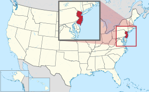
 Peta Amérika Serikat sareng New Jersey kacihnain | |||
| Negara | Amérika Serikat | ||
| Sadurung dados negara wagian | Provinsi New Jersey | ||
| Magabung sareng Serikat | 18 Désémber 1787 (ka-3) | ||
| Ibu kota | Trenton | ||
| Kota ageng | Newark | ||
| Métropolitan ageng | New York Raya | ||
| Pamréntahan | |||
| • Gubernur | Phil Murphy (D) | ||
| • Wakil Gubernur | Sheila Oliver (D) | ||
| Legislatif | Législatif New Jersey | ||
| • Majelis tinggi | Senat | ||
| • Majelis rendah | Majelis Umum | ||
| Kahakiman | Mahkamah Agung New Jersey | ||
| Senator AS | Bob Menendez (D) Cory Booker (D) | ||
| Délegasi DPR AS | 10 Démokrat 2 Républik (lis) | ||
| Jimbar | |||
| • Total | 8,722,58 sq mi (22,591,38 km2) | ||
| • Darat | 7,354,22[2] sq mi (19,047,34 km2) | ||
| • Air | 1,368,36 sq mi (3,544,04 km2) 15.7% | ||
| Peringkat jimbar wawidangan | ka-47 | ||
| Dimensions | |||
| • Panjang | 170 mi (273 km) | ||
| • Lebar | 70 mi (112 km) | ||
| Ketinggian | 250 ft (80 m) | ||
| Titik pinih tegeh | 1,803 ft (549,6 m) | ||
| Titik pinih endep (Samudra Atlantik[3]) | 0 ft (0 m) | ||
| Populasi (2020[6]) | |||
| • Total | 9,294,493 | ||
| • Peringkat | ka-11 | ||
| • Kepadatan | 1.263,08/sq mi (467/km2) | ||
| • Peringkat | ka-1 | ||
| • Médian pangupa jiwa kulawarga | $82,545[5] | ||
| • Peringkat pangupa jiwa | ka−3 | ||
| Demonim | New Jerseyan (secara resmi),[7] New Jerseyite[8][9] | ||
| Basa | |||
| • Basa resmi | Ten wénten | ||
| • Basa lisan | |||
| Wewidangan galah | UTC−05:00 (Kangin) | ||
| • Musim panas (DST) | UTC−04:00 (EDT) | ||
| Ancengan USPS | NJ | ||
| ISO 3166 code | US-NJ | ||
| Ancengan lami | N.J. | ||
| Garis lintang | 38°56′ N ke 41°21′ N | ||
| Garis bujur | 73°54′ W ke 75°34′ W | ||
| Situs web | nj | ||
| Simbol negara wagian New Jersey | |
|---|---|
 | |
 | |
| Lambang urip | |
| Paksi | Eastern Goldfinch |
| Ulam | Brook trout |
| Sekar | Viola sororia |
| Padang | None |
| Gumintit | European honey bee |
| Reptil | None |
| Taru | Quercus rubra |
| Inanimate insignia | |
| Beverage | None |
| Colors | Buff and Blue |
| Dance | Square Dance |
| Folk dance | None |
| Fossil | duck-billed dinosaur |
| Gemstone | None |
| Mineral | None |
| Motto | Liberty and prosperity |
| Nickname | The Garden State |
| Rock | None |
| Soil | Honeoye |
| Song | None |
| Tartan | None |
| State route marker | |
 | |
| Kuartal negara wagian | |
 Kawedar ring 1999 | |
| Lis simbol negara wagian Amérika Serikat | |
New Jersey inggih punika silih tunggil negara wagian ring wawengkon Mid-Atlantik miwah Northeastern Amérika Serikat. Punika mawatesan ring kalér miwah kangin sareng negara wagian New York; ring sisi kangin, kelod kangin, miwah kelod mawatesan sareng Samudra Atlantik; ring sisi kauh olih Tukad Delaware miwah Pennsylvania; taler ring kalér kauh olih Teluk Delaware miwah negara wagian Délaware.
| County |
Kode FIPS[10] | Ibukota County[11] | Kota ageng[12] | Adeg.[11] | Saking[13][14] | Kaaranin antuk[15] | Kapadetan (per mi2) | Pop.[16] | Jimbar[11] | Peta |
|---|---|---|---|---|---|---|---|---|---|---|
| County Atlantic | 001 | Mays Landing | Egg Harbor Township 47,842 | 1837 | County Gloucester | Samudra Atlantik, sané ngadegang wates kangin negara wagian ipun | 489.39 | 274.534 | 561 sq mi (1.453 km²) |

|
| County Bergen | 003 | Hackensack | Hackensack 46,030 | 1683 | Silih tunggil saking 4 county sujati sané kaadegang ring Jersey Kangin | Paumahan Bergen, New Netherland | 3,868.02 | 955.732 | 234 sq mi (606 km²) |

|
| County Burlington | 005 | Mount Holly | Evesham Township 46,826 | 1694 | Silih tunggil saking kalih county sujati sané kaadegang ring Jersey Kauh | Parinama kuna antuk pasar jeroan nampek Bridlington, Inggris | 557.43 | 461.860 | 805 sq mi (2.085 km²) |

|
| County Camden | 007 | Camden | Cherry Hill 74,553 | 1844 | County Gloucester | Charles Pratt, Earl Camden ka-1 (1714–1794), satunggil pandukung Inggris saking para penjajah ritatkala Révolusi Amérika[17] | 2,313.77 | 523.485 | 222 sq mi (575 km²) |

|
| County Cape May | 009 | Cape May Court House | Lower Township 22,057 | 1692 | County Burlington | Panjelajah Belanda abad ka-17 Cornelius Jacobsen Mey, sané nyelajahin lan nyurvei Celuk Delaware ring sisi kelod county | 381.43 | 95.263 | 255 sq mi (660 km²) |

|
| County Cumberland | 011 | Bridgeton | Vineland 60,780 | 1748 | County Salem | Rajaputra William, Duke Cumberland (1721–1765), putra kaping kalib George II saking Britania Raya lan jayanti militér ring Patempuran Culloden warsa 1746 | 320.85 | 154.152 | 489 sq mi (1.267 km²) |

|
| County Essex | 013 | Newark | Newark 311,549 | 1683 | Silih tunggil saking 4 county sujati sané kaadegang ring Jersey Kangin | County Essex ring Inggris | 6,221.98 | 863.728 | 126 sq mi (326 km²) |

|
| County Gloucester | 015 | Woodbury | Washington Township 48,677 | 1686 | County Burlington | Kota Gloucester, Inggris | 938.80 | 302.294 | 325 sq mi (842 km²) |

|
| County Hudson | 017 | Kota Jersey | Kota Jersey 292,449 | 1840 | County Bergen | Panjelajah Inggris Henry Hudson (séda 1611), sané nyelajahin atenga garis pasisi New Jersey | 13,495.02 | 724.854 | 47 sq mi (122 km²) |

|
| County Hunterdon | 019 | Flemington | Raritan Township 23,447 | 1714 | County Burlington | Robert Hunter (1664–1734), Gubernur Kolonial New Jersey saking warsa 1710 nganti 1720 | 298.49 | 128.947 | 430 sq mi (1.114 km²) |

|
| County Mercer | 021 | Trenton | Hamilton Township 92,297 | 1838 | County Burlington, County Hunterdon, County Middlesex, lan County Somerset | Tentra Kontinéntal General Hugh Mercer (1726–1777), sané padem ring Patempuran Princeton[18] | 1,621.74 | 387.340 | 226 sq mi (585 km²) |

|
| County Middlesex | 023 | New Brunswick | Edison 107,588 | 1683 | Silih tunggil saking 4 county sujati sané kaadegang ring Jersey Kangin | County malelintihan Middlesex ring Inggris | 2,604.05 | 863.162 | 311 sq mi (805 km²) |

|
| County Monmouth | 025 | Freehold Borough | Middletown Township 67,106 | 1683 | Silih tunggil saking 4 county sujati sané kaadegang ring Jersey Kangin | County malelintihan Monmouthshire ring Wales | 1,335.55 | 643.615 | 472 sq mi (1.222 km²) |

|
| County Morris | 027 | Morristown | Parsippany-Troy Hills 56,162 | 1739 | County Hunterdon | Kolonél Lewis Morris (1671–1746), gubernur kolonial New Jersey daweg nika pangadegan wawengkon punika[19][20] | 1,049.63 | 509.285 | 469 sq mi (1.215 km²) |

|
| County Ocean | 029 | Toms River | Lakewood Township 135,158 | 1850 | County Monmouth lan County Burlington | Samudra Atlantik, sané ngadegang pawatesan kangin New Jersey | 1,001.93 | 637.229 | 636 sq mi (1.647 km²) |

|
| County Passaic | 031 | Paterson | Paterson 159,732 | 1837 | County Bergen lan County Essex | "Pasaeck", kruna Lenape sané maartos "lebah" | 2,709.33 | 524.118 | 185 sq mi (479 km²) |

|
| County Salem | 033 | Salem | Pennsville Township 12,684 | 1694 | Silih tunggil saking kalih county sujati sané kaadegang ring Jersey Kauh | Kruna Basa Ibrani maartos "damé" | 195.51 | 64.837 | 338 sq mi (875 km²) |

|
| County Somerset | 035 | Somerville | Franklin Township 68,364 | 1688 | County Middlesex | County Somerset ring Inggris | 1,060.47 | 345.361 | 305 sq mi (790 km²) |

|
| County Sussex | 037 | Newton | Vernon Township 22,358 | 1753 | County Morris | County Sussex ring Inggris | 286.5 | 144.221 | 521 sq mi (1.349 km²) |

|
| County Union | 039 | Elizabeth | Elizabeth 137,298 | 1857 | County Essex | Pasikian Amérika Serikat sané kaancem olih paiyegan indik pabudakan | 5,208.73 | 575.345 | 103 sq mi (267 km²) |

|
| County Warren | 041 | Belvidere | Phillipsburg 15,249 | 1824 | County Sussex | Yuda Kamahardikaan Amérika Jénderal Joseph Warren (1741–1775), padem ring Patempuran Bunker Hill | 303.61 | 109.632 | 358 sq mi (927 km²) |

|
- ↑ The Garden State and Other New Jersey State Nicknames Archived Séptémber 2, 2019, at the Wayback Machine, Robert Lupp, New Jersey Reference Services, New Jersey State Library, October 12, 1994.
- ↑ "New Jersey". State & County QuickFacts. U.S. Census Bureau. Kaarsipin saking versi asli tanggal October 31, 2013. Kaaksés October 30, 2013.
- ↑ 3,0 3,1 "Elevations and Distances in the United States". Survei Geologi Amerika Serikat. 2001. Kaarsipin saking versi asli tanggal October 15, 2011. Kaaksés October 24, 2011.
- ↑ Ketinggian disesuaikan dengan Datum Vertikal Amerika Utara 1988.
- ↑ "Quickfacts New Jersey". United States Census Bureau. Kaaksés April 26, 2021.
- ↑ "2020 Census Apportionment Results". census.gov. United States Census Bureau. Kaarsipin saking versi asli tanggal April 26, 2021. Kaaksés April 26, 2021.
- ↑ "GPO Style Manual 2008" (PDF). Kaarsipin saking versi asli (PDF) tanggal February 21, 2011. Kaaksés July 25, 2010.
- ↑ "New Jersey—Definition and More from the Free Merriam-Webster Dictionary". Merriam-Webster. Kaarsipin saking versi asli tanggal May 31, 2013. Kaaksés June 3, 2013.
- ↑ "Definition of New Jerseyite". Dictionary.reference.com. Kaarsipin saking versi asli tanggal June 22, 2013. Kaaksés July 25, 2010.
- ↑ Pikobet nganggit: Tag
<ref>tidak sah; tidak ditemukan teks untuk ref bernamaepa - ↑ 11,0 11,1 11,2 "NACo – Find a county". National Association of Counties. Kaarsipin saking versi asli tanggal January 12, 2008. Kaaksés January 25, 2008.
- ↑ "Population Density by County and Municipality: New Jersey, 2010 and 2017" (PDF). New Jersey Department of Health. Kaarsipin (PDF) saking versi asli tanggal October 19, 2020. Kaaksés October 28, 2020.
- ↑ Pikobet nganggit: Tag
<ref>tidak sah; tidak ditemukan teks untuk ref bernamaNJAEO - ↑ Pikobet nganggit: Tag
<ref>tidak sah; tidak ditemukan teks untuk ref bernamaTorp - ↑ Hutchinson, Viola L. The Origin of New Jersey Place Names Archived 2015-11-15 at the Wayback Machine, New Jersey Public Library Commission, May 1945. Accessed November 14, 2015.
- ↑ "U.S. Census Bureau QuickFacts: New Jersey". Kaarsipin saking versi asli tanggal 2021-10-24. Kaaksés 2021-08-17.
- ↑ Greenberg, Gail (August 30, 2009). "A Brief History of Camden County". Camden County Board of Freeholders. Kaarsipin saking versi asli tanggal June 23, 2009. Kaaksés August 31, 2009.
- ↑ "History". Mercer County Cultural & Heritage Commission. Kaarsipin saking versi asli tanggal February 21, 2009. Kaaksés August 31, 2009.
- ↑ "The Land Past and Present". Morris County Board of Chosen Freeholders. Kaarsipin saking versi asli tanggal August 22, 2009. Kaaksés August 30, 2009.
- ↑ "How did our county get its name?". Morris County Library. July 26, 2008. Kaarsipin saking versi asli tanggal February 23, 2009. Kaaksés August 31, 2009.
Kategori:
- Kaca antuj argumén formatnum ten-wilangan
- Kaca antuk argumén ganda ring pangrauhan mal
- Kaca antuk galat pustaka
- Kaca sané nganggén kotakinpo Simbol negara wagian AS sareng paraméter sané nénten kauningin
- Suratan Wikipédia sareng penanda BIBSYS
- Kaca sareng kategori pengawasan otoritas belum dibuat
- Suratan Wikipédia sareng penanda BNE
- Suratan Wikipédia sareng penanda NLA
- Suratan Wikipédia sareng penanda NLI
- Suratan Wikipédia sareng penanda NSK
- Suratan Wikipédia sareng penanda CINII
- Suratan Wikipédia sareng penanda FAST
- Suratan Wikipédia sareng penanda MusicBrainz area
- Suratan Wikipédia sareng penanda NARA
- Suratan Wikipédia sareng penanda RERO
- Suratan Wikipédia sareng penanda Trove
- Suratan Wikipédia sareng penanda WorldCat-VIAF
- New Jersey
- Negara wagian ring Amérika Serikat


