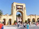
Orlando, Florida
Tampilan
| Orlando | |||
|---|---|---|---|
| |||
| Julukan: The City Beautiful, O-Town, Theme Park Capital of the World | |||
 Interactive map of Orlando | |||
| Koordinat: 28°32′24″N 81°22′48″W / 28.54000°N 81.38000°W[1] | |||
| Country | United States | ||
| State | Florida | ||
| County | Orange | ||
| Settled | 1843 (Jernigan) | ||
| Incorporated (town) | July 31, 1875 | ||
| Incorporated (city) | February 4, 1885 | ||
| Pamréntahan | |||
| • Jenis | Strong Mayor–Council | ||
| • Mayor | Buddy Dyer (D) | ||
| • City council | Members
| ||
| Jimbar | |||
| • Total | 119,08 sq mi (308,41 km2) | ||
| • Darat | 110,85 sq mi (287,10 km2) | ||
| • Air | 8,23 sq mi (21,31 km2) | ||
| • Kota | 644,61 sq mi (166,950 km2) | ||
| Ketinggian | 89 ft (27 m) | ||
| Populasi (2020) | |||
| • Total | 307.573 | ||
| • Peringkat | 67th, U.S. | ||
| • Kepadatan | 2.774,65/sq mi (1.071,30/km2) | ||
| • Kota | 1,853,896 (26th, U.S.) | ||
| • Kepadatan kota | 2,876,0/sq mi (1,110,4/km2) | ||
| • Metro | 2,691,925 (23rd, U.S.) | ||
| • CSA | 4,222,422 (15th, U.S.) | ||
| Demonim | Orlandoan | ||
| GDP | |||
| • Orlando (MSA) | $194.5 billion (2022) | ||
| Wewidangan galah | UTC−5 (EST) | ||
| • Musim panas (DST) | UTC−4 (EDT) | ||
| ZIP Code | 32801-32812, 32814-32822, 32824-32837, 32839, 32853-32862, 32867-32869, 32872, 32877-32878, 32885-32887, 32891, 32896-32897, 32899 | ||
| Kode wawengkon | 407, 689 | ||
| FIPS code | 12-53000 | ||
| GNIS feature ID | 2404443[1] | ||
| Situs web | www.orlando.gov | ||
Orlando (/ɔːrˈlændoʊ/ or-LAN-doh) inggih punika satunggil kota lan kursi county saking, County Orange, Florida, Amérika Serikat. Pahan saking Florida Tengah, niki magenah ring pusat wawengkon métropolitan Orlando S
- ↑ 1,0 1,1 1,2 U.S. Geological Survey Geographic Names Information System: Orlando, Florida
- ↑ "2020 U.S. Gazetteer Files". United States Census Bureau. Kaaksés October 31, 2021.
- ↑ "Total Gross Domestic Product for Orlando-Kissimmee-Sanford, FL (MSA)". fred.stlouisfed.org.


