
Berkas:Lake Huron bathymetry map.png
Berkas sujati (936x1.024 piksel, agengnyané berkas: 1,35 MB, soroh MIME:image/png)
Ringkesan
| Déskripsi |
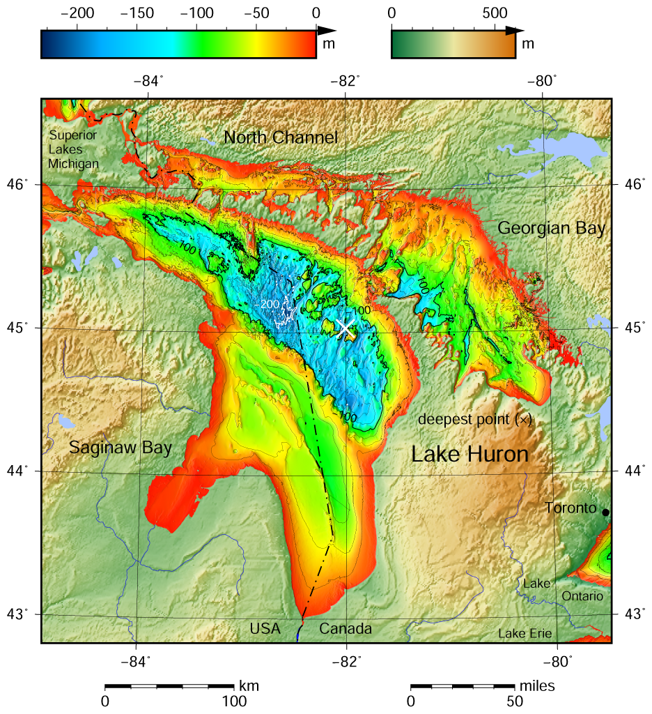
English: Lake Huron bathymetric shaded relief map contoured with interval 25 m (100 m with thicker lines). The deepest point is marked with "×". For land the vertical datum is sea level, for bathymetry low water datum of the lake. The map was created using the Generic Mapping Tools, GMT, version 5.1.1. |
| Tanggal | |
| Wit |
Own work using: the following Public Domain datasets (grids):
The coordinates of deepest point are taken from the NOAA Great LakesEnvironmental Research Laboratory webpage (www.glerl.noaa.gov/, kml file Google Earth Great Lakes Tour). Gambar ini dibuat menggunakan GMT. |
| Sang anyurat | Darekk2 using the Great Lakes Bathymetry and GLOBE tiles |
| Versi lainnya |
|

Lisénsi
Attribution (in addition to the author of this map):
The NGDC in it's copyright notice says:
As required by 17 U.S.C. 403, third parties producing copyrighted works consisting predominantly of the material produced by U.S. government agencies must provide notice with such work(s) identifying the U.S. Government material incorporated and stating that such material is not subject to copyright protection within the United States. (...)
(for credits see the Source section).
and Great Lakes Bathymetry and GLOBE
(see above and the Source section)
- Ida kadadosang:
- Ngedum – Nyadur miwah nyobyahang malih suratan puniki ring wentuk utawi format napi ja
- Nyampuhang – Ngubah pakaryan puniki
- Ring sor kawéntenan puniki:
- atribusi – Ragané patut ngenahang krédit sané patut, ngicénin pranala lisénsinnyané, miwah nguningaang yéning ngardi uahan. Ragané prasida nglaksanaang nganggé tata cara sané sumakuta, nanging nénten mateges yéning sang ngicénin lisénsi nyokong ragané utawi panganggén ragané.
- wagiang pateh – Yening ragane nyampuh, ngubah, utawi ngwangun ring ajeng pakaryan, Ida patuh nyobyahang kontribusi druene ring ungkur lisensi sane pateh utawi kompatibel manut sujatinyane
Babad berkas
Klik ring tanggal/galah anggén nyingakin berkas puniki ri tatkala galah punika.
| Tanggal/Galah | Gambar alit | Diménsi | Sang anganggé | Panampen | |
|---|---|---|---|---|---|
| mangkin | 10 Méi 2015 20.21 | | 936 × 1.024 (1,35 MB) | Darekk2 | a small island in NE Michigan |
| 9 Méi 2015 02.00 |  | 936 × 1.024 (1,35 MB) | Darekk2 | forgot about few islands in south ... !! | |
| 9 Méi 2015 00.57 |  | 936 × 1.024 (1,35 MB) | Darekk2 | thicker deepest point mark | |
| 8 Méi 2015 23.27 |  | 936 × 1.024 (1,35 MB) | Darekk2 | User created page with UploadWizard |
Panganggén berkas
Kaca nganggén berkas puniki:
Panganggén berkas ring jagat
Wiki lianan ring sor puniki nganggén berkas puniki:
- Panganggén ring en.wikipedia.org
- Panganggén ring id.wikipedia.org
- Panganggén ring kn.wikipedia.org
- Panganggén ring th.wikipedia.org
- Panganggén ring vi.wikipedia.org
- Panganggén ring www.wikidata.org